Floodplain management is the implementation of preventative or corrective measures taken by a community to reduce the impacts of flood damage.
This can include emergency preparedness plans, construction of flood control structures, or regulations that guide communities toward responsible building inside and near the floodplain.
Common Floodplain Management Terms
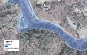
One Hundred Year Flood: The 100-year flood, also called the base flood, is the flood that has a one percent (1%) chance of being equaled or exceeded in any given year.
Floodplain: A floodplain is any land susceptible to being inundated by water.
Floodway: A floodway is a channel of a river or other watercourse and adjacent land that must be reserved in order to pass the 100-year flood without increasing the elevation more than a designated height.
Flood Insurance Rate Map (FIRM): The Flood Insurance Rate Map (FIRM) is designed to illustrate special flood hazard areas, e.g., the limits of the floodway, floodplain, and 100-year flood.
Flood Insurance Study (FIS): The Flood Insurance Study (FIS) provides detailed information for a watercourse for which a detailed study has been performed. Your local flood insurance study can provide base flood elevations.
Loading
Loading
[{"WidgetSkinID":43,"ComponentType":0,"FontFamily":"","FontVariant":"","FontColor":"","FontSize":0.00,"FontStyle":0,"TextAlignment":1,"ShadowColor":"","ShadowBlurRadius":0,"ShadowSpreadRadius":0,"ShadowOffsetX":0,"ShadowOffsetY":0,"ShadowInset":false,"ShadowColor2":"","ShadowBlurRadius2":0,"ShadowSpreadRadius2":0,"ShadowOffsetX2":0,"ShadowOffsetY2":0,"ShadowInset2":false,"ShadowColor3":"","ShadowBlurRadius3":0,"ShadowSpreadRadius3":0,"ShadowOffsetX3":0,"ShadowOffsetY3":0,"ShadowInset3":false,"ShadowColor4":"","ShadowBlurRadius4":0,"ShadowSpreadRadius4":0,"ShadowOffsetX4":0,"ShadowOffsetY4":0,"ShadowInset4":false,"ShadowColor5":"","ShadowBlurRadius5":0,"ShadowSpreadRadius5":0,"ShadowOffsetX5":0,"ShadowOffsetY5":0,"ShadowInset5":false,"Capitalization":0,"HeaderMiscellaneousStyles1":"","HeaderMiscellaneousStyles2":"","HeaderMiscellaneousStyles3":"","BulletStyle":0,"BulletWidth":2.00,"BulletColor":"","LinkNormalColor":"","LinkNormalUnderlined":false,"LinkNormalMiscellaneousStyles":"","LinkVisitedColor":"","LinkVisitedMiscellaneousStyles":"","LinkHoverColor":"","LinkHoverUnderlined":false,"LinkHoverMiscellaneousStyles":"","LinkSelectedUnderlined":false,"ForceReadOnLinkToNewLine":false,"DisplayColumnSeparator":false,"ColumnSeparatorWidth":0.0000,"HoverBackgroundColor":"","HoverBackgroundGradientStartingColor":"","HoverBackgroundGradientEndingColor":"","HoverBackgroundGradientDirection":0,"HoverBackgroundGradientDegrees":0.0000000,"HoverBackgroundImageFileName":"","HoverBackgroundImagePositionXUseKeyword":true,"HoverBackgroundImagePositionXKeyword":0,"HoverBackgroundImagePositionX":{"Value":0.0000,"Unit":0},"HoverBackgroundImagePositionYUseKeyword":true,"HoverBackgroundImagePositionYKeyword":0,"HoverBackgroundImagePositionY":{"Value":0.0000,"Unit":0},"HoverBackgroundImageRepeat":0,"HoverBorderStyle":0,"HoverBorderWidth":0,"HoverBorderColor":"","HoverBorderSides":15,"HoverBorderRadiusTopLeft":{"Value":null,"Unit":1},"HoverBorderRadiusTopRight":{"Value":null,"Unit":1},"HoverBorderRadiusBottomRight":{"Value":null,"Unit":1},"HoverBorderRadiusBottomLeft":{"Value":null,"Unit":1},"SelectedBackgroundColor":"","SelectedBackgroundGradientStartingColor":"","SelectedBackgroundGradientEndingColor":"","SelectedBackgroundGradientDirection":0,"SelectedBackgroundGradientDegrees":0.0000000,"SelectedBackgroundImageFileName":"","SelectedBackgroundImagePositionXUseKeyword":true,"SelectedBackgroundImagePositionXKeyword":0,"SelectedBackgroundImagePositionX":{"Value":0.0000,"Unit":0},"SelectedBackgroundImagePositionYUseKeyword":true,"SelectedBackgroundImagePositionYKeyword":0,"SelectedBackgroundImagePositionY":{"Value":0.0000,"Unit":0},"SelectedBackgroundImageRepeat":0,"SelectedBorderStyle":0,"SelectedBorderWidth":0,"SelectedBorderColor":"","SelectedBorderSides":15,"SelectedBorderRadiusTopLeft":{"Value":null,"Unit":1},"SelectedBorderRadiusTopRight":{"Value":null,"Unit":1},"SelectedBorderRadiusBottomRight":{"Value":null,"Unit":1},"SelectedBorderRadiusBottomLeft":{"Value":null,"Unit":1},"HoverFontFamily":"","HoverFontVariant":"","HoverFontColor":"","HoverFontSize":0.00,"HoverFontStyle":0,"HoverTextAlignment":0,"HoverShadowColor":"","HoverShadowBlurRadius":0,"HoverShadowSpreadRadius":0,"HoverShadowOffsetX":0,"HoverShadowOffsetY":0,"HoverShadowInset":false,"HoverShadowColor2":"","HoverShadowBlurRadius2":0,"HoverShadowSpreadRadius2":0,"HoverShadowOffsetX2":0,"HoverShadowOffsetY2":0,"HoverShadowInset2":false,"HoverShadowColor3":"","HoverShadowBlurRadius3":0,"HoverShadowSpreadRadius3":0,"HoverShadowOffsetX3":0,"HoverShadowOffsetY3":0,"HoverShadowInset3":false,"HoverShadowColor4":"","HoverShadowBlurRadius4":0,"HoverShadowSpreadRadius4":0,"HoverShadowOffsetX4":0,"HoverShadowOffsetY4":0,"HoverShadowInset4":false,"HoverShadowColor5":"","HoverShadowBlurRadius5":0,"HoverShadowSpreadRadius5":0,"HoverShadowOffsetX5":0,"HoverShadowOffsetY5":0,"HoverShadowInset5":false,"HoverCapitalization":0,"SelectedFontFamily":"","SelectedFontVariant":"","SelectedFontColor":"","SelectedFontSize":0.00,"SelectedFontStyle":0,"SelectedShadowColor":"","SelectedShadowBlurRadius":0,"SelectedShadowSpreadRadius":0,"SelectedShadowOffsetX":0,"SelectedShadowOffsetY":0,"SelectedShadowInset":false,"SpaceBetweenTabs":0,"SpaceBetweenTabsUnits":"","Trigger":4,"AnimationId":"00000000-0000-0000-0000-000000000000","AnimationClass":"animation00000000000000000000000000000000","ScrollOffset":33,"TriggerNameLowerCase":"scroll","ParentComponentWithTrigger":null,"BackgroundColor":"","BackgroundGradientStartingColor":"","BackgroundGradientEndingColor":"","BackgroundGradientDirection":0,"BackgroundGradientDegrees":0.0000000,"BackgroundImageFileName":"","BackgroundImagePositionXUseKeyword":true,"BackgroundImagePositionXKeyword":0,"BackgroundImagePositionX":{"Value":0.0,"Unit":0},"BackgroundImagePositionYUseKeyword":true,"BackgroundImagePositionYKeyword":0,"BackgroundImagePositionY":{"Value":0.0,"Unit":0},"BackgroundImageRepeat":0,"BorderStyle":0,"BorderWidth":0,"BorderColor":"","BorderSides":15,"BorderRadiusTopLeft":{"Value":null,"Unit":1},"BorderRadiusTopRight":{"Value":null,"Unit":1},"BorderRadiusBottomRight":{"Value":null,"Unit":1},"BorderRadiusBottomLeft":{"Value":null,"Unit":1},"MarginTop":{"Value":null,"Unit":0},"MarginRight":{"Value":null,"Unit":0},"MarginBottom":{"Value":null,"Unit":0},"MarginLeft":{"Value":null,"Unit":0},"PaddingTop":{"Value":null,"Unit":0},"PaddingRight":{"Value":null,"Unit":0},"PaddingBottom":{"Value":null,"Unit":0},"PaddingLeft":{"Value":null,"Unit":0},"MiscellaneousStyles":"}\n\n.widget.skin43 .fr-view p {\nmargin-bottom: 0;\n}\n\nbody.narrow .widget.skin43 {\nfont-size: .75em;","RecordStatus":0},{"WidgetSkinID":55,"ComponentType":0,"FontFamily":"","FontVariant":"","FontColor":"","FontSize":0.00,"FontStyle":0,"TextAlignment":1,"ShadowColor":"","ShadowBlurRadius":0,"ShadowSpreadRadius":0,"ShadowOffsetX":0,"ShadowOffsetY":0,"ShadowInset":false,"ShadowColor2":"","ShadowBlurRadius2":0,"ShadowSpreadRadius2":0,"ShadowOffsetX2":0,"ShadowOffsetY2":0,"ShadowInset2":false,"ShadowColor3":"","ShadowBlurRadius3":0,"ShadowSpreadRadius3":0,"ShadowOffsetX3":0,"ShadowOffsetY3":0,"ShadowInset3":false,"ShadowColor4":"","ShadowBlurRadius4":0,"ShadowSpreadRadius4":0,"ShadowOffsetX4":0,"ShadowOffsetY4":0,"ShadowInset4":false,"ShadowColor5":"","ShadowBlurRadius5":0,"ShadowSpreadRadius5":0,"ShadowOffsetX5":0,"ShadowOffsetY5":0,"ShadowInset5":false,"Capitalization":0,"HeaderMiscellaneousStyles1":"","HeaderMiscellaneousStyles2":"","HeaderMiscellaneousStyles3":"","BulletStyle":0,"BulletWidth":2.00,"BulletColor":"","LinkNormalColor":"","LinkNormalUnderlined":false,"LinkNormalMiscellaneousStyles":"","LinkVisitedColor":"","LinkVisitedMiscellaneousStyles":"","LinkHoverColor":"","LinkHoverUnderlined":false,"LinkHoverMiscellaneousStyles":"","LinkSelectedUnderlined":false,"ForceReadOnLinkToNewLine":false,"DisplayColumnSeparator":false,"ColumnSeparatorWidth":0.0000,"HoverBackgroundColor":"","HoverBackgroundGradientStartingColor":"","HoverBackgroundGradientEndingColor":"","HoverBackgroundGradientDirection":0,"HoverBackgroundGradientDegrees":0.0000000,"HoverBackgroundImageFileName":"","HoverBackgroundImagePositionXUseKeyword":true,"HoverBackgroundImagePositionXKeyword":0,"HoverBackgroundImagePositionX":{"Value":0.0000,"Unit":0},"HoverBackgroundImagePositionYUseKeyword":true,"HoverBackgroundImagePositionYKeyword":0,"HoverBackgroundImagePositionY":{"Value":0.0000,"Unit":0},"HoverBackgroundImageRepeat":0,"HoverBorderStyle":0,"HoverBorderWidth":0,"HoverBorderColor":"","HoverBorderSides":15,"HoverBorderRadiusTopLeft":{"Value":null,"Unit":1},"HoverBorderRadiusTopRight":{"Value":null,"Unit":1},"HoverBorderRadiusBottomRight":{"Value":null,"Unit":1},"HoverBorderRadiusBottomLeft":{"Value":null,"Unit":1},"SelectedBackgroundColor":"","SelectedBackgroundGradientStartingColor":"","SelectedBackgroundGradientEndingColor":"","SelectedBackgroundGradientDirection":0,"SelectedBackgroundGradientDegrees":0.0000000,"SelectedBackgroundImageFileName":"","SelectedBackgroundImagePositionXUseKeyword":true,"SelectedBackgroundImagePositionXKeyword":0,"SelectedBackgroundImagePositionX":{"Value":0.0000,"Unit":0},"SelectedBackgroundImagePositionYUseKeyword":true,"SelectedBackgroundImagePositionYKeyword":0,"SelectedBackgroundImagePositionY":{"Value":0.0000,"Unit":0},"SelectedBackgroundImageRepeat":0,"SelectedBorderStyle":0,"SelectedBorderWidth":0,"SelectedBorderColor":"","SelectedBorderSides":15,"SelectedBorderRadiusTopLeft":{"Value":null,"Unit":1},"SelectedBorderRadiusTopRight":{"Value":null,"Unit":1},"SelectedBorderRadiusBottomRight":{"Value":null,"Unit":1},"SelectedBorderRadiusBottomLeft":{"Value":null,"Unit":1},"HoverFontFamily":"","HoverFontVariant":"","HoverFontColor":"","HoverFontSize":0.00,"HoverFontStyle":0,"HoverTextAlignment":0,"HoverShadowColor":"","HoverShadowBlurRadius":0,"HoverShadowSpreadRadius":0,"HoverShadowOffsetX":0,"HoverShadowOffsetY":0,"HoverShadowInset":false,"HoverShadowColor2":"","HoverShadowBlurRadius2":0,"HoverShadowSpreadRadius2":0,"HoverShadowOffsetX2":0,"HoverShadowOffsetY2":0,"HoverShadowInset2":false,"HoverShadowColor3":"","HoverShadowBlurRadius3":0,"HoverShadowSpreadRadius3":0,"HoverShadowOffsetX3":0,"HoverShadowOffsetY3":0,"HoverShadowInset3":false,"HoverShadowColor4":"","HoverShadowBlurRadius4":0,"HoverShadowSpreadRadius4":0,"HoverShadowOffsetX4":0,"HoverShadowOffsetY4":0,"HoverShadowInset4":false,"HoverShadowColor5":"","HoverShadowBlurRadius5":0,"HoverShadowSpreadRadius5":0,"HoverShadowOffsetX5":0,"HoverShadowOffsetY5":0,"HoverShadowInset5":false,"HoverCapitalization":0,"SelectedFontFamily":"","SelectedFontVariant":"","SelectedFontColor":"","SelectedFontSize":0.00,"SelectedFontStyle":0,"SelectedShadowColor":"","SelectedShadowBlurRadius":0,"SelectedShadowSpreadRadius":0,"SelectedShadowOffsetX":0,"SelectedShadowOffsetY":0,"SelectedShadowInset":false,"SpaceBetweenTabs":0,"SpaceBetweenTabsUnits":"","Trigger":4,"AnimationId":"00000000-0000-0000-0000-000000000000","AnimationClass":"animation00000000000000000000000000000000","ScrollOffset":33,"TriggerNameLowerCase":"scroll","ParentComponentWithTrigger":null,"BackgroundColor":"","BackgroundGradientStartingColor":"","BackgroundGradientEndingColor":"","BackgroundGradientDirection":0,"BackgroundGradientDegrees":0.0000000,"BackgroundImageFileName":"","BackgroundImagePositionXUseKeyword":true,"BackgroundImagePositionXKeyword":0,"BackgroundImagePositionX":{"Value":0.0,"Unit":0},"BackgroundImagePositionYUseKeyword":true,"BackgroundImagePositionYKeyword":0,"BackgroundImagePositionY":{"Value":0.0,"Unit":0},"BackgroundImageRepeat":0,"BorderStyle":0,"BorderWidth":0,"BorderColor":"","BorderSides":15,"BorderRadiusTopLeft":{"Value":null,"Unit":1},"BorderRadiusTopRight":{"Value":null,"Unit":1},"BorderRadiusBottomRight":{"Value":null,"Unit":1},"BorderRadiusBottomLeft":{"Value":null,"Unit":1},"MarginTop":{"Value":null,"Unit":0},"MarginRight":{"Value":null,"Unit":0},"MarginBottom":{"Value":null,"Unit":0},"MarginLeft":{"Value":null,"Unit":0},"PaddingTop":{"Value":null,"Unit":0},"PaddingRight":{"Value":null,"Unit":0},"PaddingBottom":{"Value":null,"Unit":0},"PaddingLeft":{"Value":null,"Unit":0},"MiscellaneousStyles":"}\n \n.widget.skin55 .fr-view p {\nmargin-bottom: 0;\n}\n\nbody.narrow .widget.skin55 {\nfont-size: .75em;","RecordStatus":0}]
 Reducing Flood Damage